The Landslide from Above
An independent, neutral information hub tracking the land movement emergency on the Palos Verdes Peninsula — the data, the history, the public meetings, the official reports, and the programs available to affected residents.
From the City of Rancho Palos Verdes' most recent survey data (early July 2026). See Maps & Data for detail and sources.
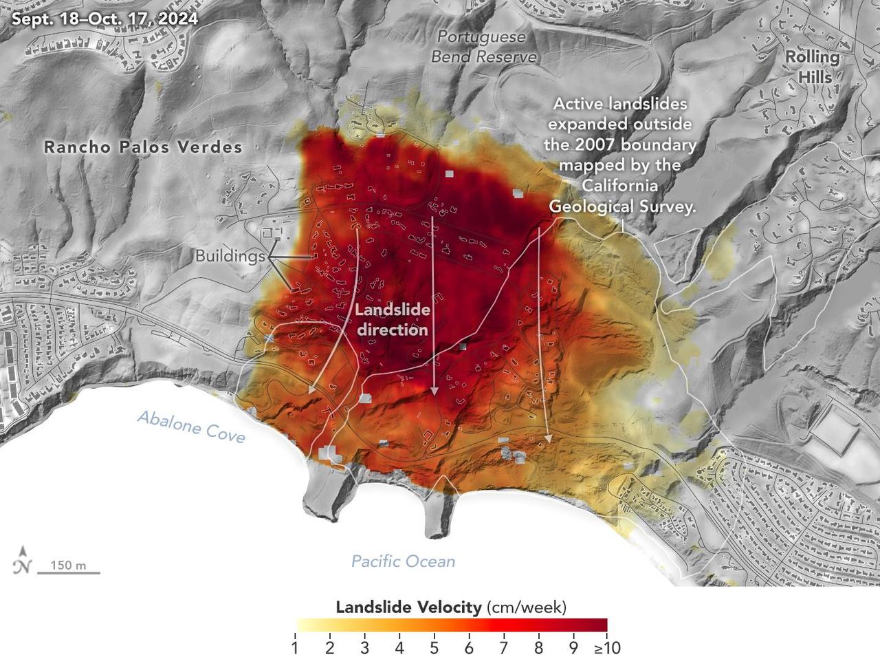
The southern slope of the Palos Verdes Peninsula sits atop an ancient landslide complex covering roughly two square miles. Part of it — the Greater Portuguese Bend Landslide Complex — has been moving since 1956, when construction fill reactivated the ancient slide. It includes four connected landslides: Portuguese Bend, Abalone Cove, Klondike Canyon, and the Beach Club slide.
After record rains in 2023 and 2024, movement accelerated dramatically — in places reaching several inches per week — damaging hundreds of homes, breaking roads and utility lines, forcing power and gas shutoffs, and prompting the dismantling of the historic Wayfarers Chapel. Federal, state, and city agencies responded with emergency declarations, buyout programs, and a major dewatering effort that has since slowed the land significantly.
Dated entries tracking survey results, dewatering progress, council decisions, utility restorations, and road work as they happen.
Read the updates →From the ancient slide and the 1956 reactivation to the 2023–24 acceleration: a full timeline plus the geology underneath it all.
Learn the history →City Council landslide updates, the weekly Landslide Complex Working Group, and the ACLAD and KCLAD abatement districts.
Track the meetings →Official land movement reports, GPS survey data, the remediation project EIR, NASA/JPL analyses, and key scientific papers.
Browse the documents →Where the land is moving and how fast — city GPS surveys, NASA radar imagery, and landslide boundary maps explained.
See the data →Everything affected homeowners need: the buyout program, financial assistance, utilities, tax relief, insurance realities, and permits.
Get resources →| Topic | Detail |
|---|---|
| Active area | The Greater Portuguese Bend Landslide Complex spans roughly 700 acres within a ~2-square-mile ancient landslide on the peninsula's south side. |
| Moving since | 1956 (Portuguese Bend), 1974 (Abalone Cove), ~1980 (Klondike Canyon). The 2023–24 storms triggered the fastest movement ever recorded here. |
| Peak movement | Up to roughly 4 inches per week in residential areas in fall 2024 (NASA/JPL radar), with some areas faster at the peak of the acceleration. |
| Homes affected | About 650 homes sit in the affected communities — Portuguese Bend, Seaview, the Portuguese Bend Beach Club, and neighboring areas. |
| Response | Local emergency declarations, deep dewatering wells, hydraugers, winterization, FEMA/Cal OES-funded buyouts, and a $33M remediation project in environmental review. |
| Today | Movement has slowed sharply since late 2024. Seaview and the Beach Club have shown little to no measurable movement in 2026; interior portions of the slide still creep. |
Figures compiled from City of Rancho Palos Verdes land movement updates, NASA/JPL, and news reporting. See Reports & Documents for sources.
If you own property or live in the land movement area, there are active programs and protections you should know about — some with deadlines.
Life-threatening emergency: call 911.
Emergency alerts: text ALERTRPV to 888-777 to register with Alert SouthBay.
Evacuation zones: know your zone at PVPready.gov.
Disaster Distress Helpline: 1-800-985-5990 (24/7 free counseling).
Have a report, meeting notice, photo, or correction we should include? Send it to contact@pvlandslide.com.